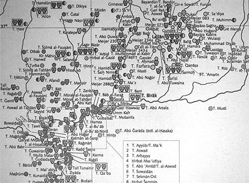
Fig. 1: Mesopotamia, early dynastic era (Uwe Finkbeiner - Wolfgang Röllig, Tübinger Atlas des Vorderen Orients [1988] B II 7 )
| Forum Archaeologiae - Zeitschrift für klassische Archäologie 13 / XII / 1999 |
1.3. All activities of the Vienna - Archaeos team concernd the exploration of "a previously unexcavated sector of the site, i.e. the north-western corner of Arbid's citatel", called "sector D". This region was assigned to our group by Professor Bielinski from the Syrian-Polish team [2]. In general, the Syrian-Polish procedures of documentation were applied.
1.3.1. Within this "sector D" ultimately eight trenches were opened, known as D 32/44, D 32/45, D 33/46, and D 30/43, D 29/43, D 29/42, D 28/43, D 28/42. A surface sample with a sizable amount of Niniveh V pottery suggested that the third millennium levels would be reached not far below the surface.
2. The work started in the trenches D 32/44, D32/45 and D 33/46, near the end of the citadels's slope. Initially it was hoped that a broader surface scraping would allow us to map out the architecture within a larger area, in order get a clearer idea of the urban developement of Arbid and, if possible, perhaps even of the occupational scheme in the third millennium. However, the scraping and digging down to a depth of approxiamtely 25 cm (D 32/44) or 50 cm (D33/46 and D 32/45) yielded no architectural remains. Thus we concluded that within this trough-like region, between the slope of the citadel and an outwardly elevation, which in fact might conceal the remnants of the cities fortification structures, we had a fill of debris and soil washed down from the citadel. In the squares D 32/44 and D 33/46 activities were therefore abandoned. To test that hypothesis, it was decided to undertake a deep sounding in square D 32/45 in an reduced 4x4 m area in its north-eastern part. Below the 20 cm or so of the surface layer, two layers of a darker and more compacted earth were found. Below, there was a layer of about 60 cm thickness, which turned out to be a fill of almost sterile soil, not even yielding significant pottery sherds. It was decided to go even further down, in order to get some understanding of this rather strange observations. There we found a sequence of layers, containing some sherds, bones, ashes and decayed libn, including a broader ash-layer (fig. 2). Since the lower levels contained a sizable number of Habur-pottery it was finally decided to close this sounding, because there was little hope to reach any third millennium levels in the remaining time and the work-force was urgently needed in the other squares. The most spectacular find in this square was a ED IIIB cylinder seal, unfortunately out of any context (fig. 3).
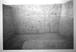
Fig. 2: View of the sections in the deep-sounding in square D 32/45 |
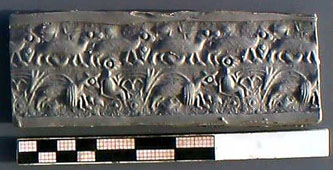 Fig. 3: Late ED IIIB (perhaps early Old Akkadian) cylinder seal from square D 32/45 |
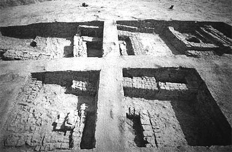
3. Meanwhile the focus of our excavations had moved to the squares D 30/43, D 29/43, and D 28/43, where the western region trenches of 9x5 m (little more than a half square) were opened succeedingly. The whole area was chosen on account of Sir Max Mallowan's claim that he had there located the city wall, a statement which was supported by the claims of the villagers that in this area remnants of the wall were visible several generations ago. To the east of the Wadi-like gap, traces of Mallowan's trenches are still visible. The aforementioned trenches of the Vienna team were situated to the west of this gap, starting with square D 30/43 close to an elevation, the others adjoining in the slope running down towards the north. Because the 'Wadi' sloping down towards the east, were the modern meandering road leads towards Tell Muzan, ancient Urke$, we speculated that the gap in fact might have to do with one of the ancient city's gates, and that the elevation where our digging was begun might hide remnants of the ancient gate house (fig. 4). All the trenches of this area yielded, just below the surface soil, various levels of architectural remains. A considerable number of graves, chiefly of a much later date, were sunk into these earlier levels.
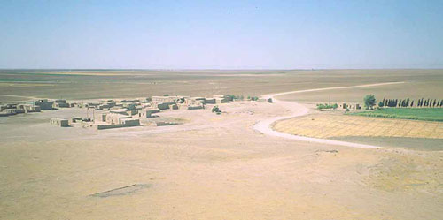
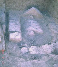 Fig. 5: 'Grave 2' (D 30/43) |
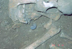
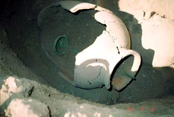
3.1.1. In D 30/43 all together five graves were detected. The best preserved and most spectacular one is known as 'Grave 2', remarkable for its state of preservation of for its findings, which allow for a date in the Hellenistic period. This rectangular grave was walled by mud-bricks, the burial itself was covered by a row of diagonally set rectangular bricks of 40x40 cm (fig. 5). Having removed those, we found a rather well preserved skeleton with its head to the east, and which contained in its mouth, facing the south, a detoriated silver coin, the well-known obolos to be paid to the ferryman by dead as a fee for crossing the underworld river (fig. 6). Facing the head was a wine jar, the opening cupped with a bronze bowl, and the laddle still hanging inside (fig. 7).
|
|
|
|
3.2. Adjoining to the north is trench D 29/43. In the most southern part, due to the baulk, the conjunction to the northernmost wall of D 30/43 remains unclear. However, joining to the north the remnants of two buildings were detected, a larger one to the east, a smaller to the west. The evidence shows that these rooms had several phases of rebuilding, which, following the ceramic evidence, all belong to the later phase of ED III. A considerable number of scattered bones were found in this square, which, togehter with the number of excavated burials, allow for the assumption that the whole area may have been reused as a cemetery at certain times. |
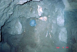
Fig. 8: The remnants of the burial and the two accompanying vessels of the second millennium 'Grave 4' from square D 30/43 |
3.2.1. In the most eastern of the just mentioned buildings, an intrusive shaft was found, which we dug down to a depth of more than 2 meters. The digging was started on a grave at the top of the shaft, containing just some human bones. The second grave, at the shaft's bottom, found after taking out a filling of ashes and earth, contained a very nice bowl, a piece of the so-called metallic ware. In fact at its bottom, the shaft was cut through a mud-brick wall, dated, by ceramic finds, most probably to the Niniveh V period. Closer observations suggest, that the burial at the bottom was hit incidently by the diggers of this shaft, and that the burial had in fact no original conjunction with it.
3.2.2. As mentioned before, the southern part of D 29/43 contained various traces of burials, most of them destroyed by erosion or plundering. Even without proper archaeological context, a number of small finds deserves mentioning here: Two geometrically incised cylinder seals, two bronze pins, and a considerable number of animal figurines.
4. Summary: This first excavation undertaken by the Institut für Orientalistik of the University of Vienna has to be considered as a first step to promote field-archaeology at its renowned department. Thanks to the scholarly advise of D. Gimbel and P. Zimmerman and due to the substantial financial support of Archaeos, Inc., this expedition became a considerable success. Nevertheless, without the overwhelming enthusiasm of our students, none of the above mentioned goals would have been achieved. The importance of the fact that, besides the astonishing number of museum items - over 65 objects just from our 'little hole' -, we were able to uncover a whole, though small, area of Niniveh V buildings which includes a milling area, and, most probably, adjoinig some administrative facilities, needs no further underlining. Thus, besides the so-called public-building, excavated by our Polish colleagues, a continuation of the excavations at Tell Arbid even in 'our' "sector D" is bound to provide further insight in the earlier history of the Jezireh.
[1] Archaeos, Inc. is a non-profit organization dedicated to education and to archaeological research and based in New York City.
[2] I wish to thank Professor P. Bielinski and his team for the invitation and their hospitality, which allowed us to make use of their bathrooms and who generously ceeded the use of one of their rooms to our girls. Our special thanks go to the Syrian co-director Ahmed Serrije, who showed continuing interest in our work and was helpful in every respect. Last not least we wish to thank the Syrian authorities, e.g. Director General of DGAM, Dr. Sultan Moheissen, Damascus, and the Regional Director of Antiquities in Hassake, Abdel Messije Bardo, for their kind hospitality and help.
© Gebhard J. Selz with D. Gimbel for the Vienna team
e-mail: Gebhard.Selz@univie.ac.at
This article will be quoted by G. J. Selz - D. Gimbel, An Austrian-American Expedition to Northern Syria, Forum Archaeologiae 13/XII/99 (http://farch.net).