| Forum Archaeologiae - Zeitschrift für klassische Archäologie 73 / XII / 2014 |
The Colophon project, started in 2010 by the Mimar Sinan University of Istanbul and conducted in close collaboration with the University of Vienna, continued also in 2014 [1]. During the fifth campaign research of the Austrian team concentrated mainly on surveying the territory of the town enclosed by the Early Hellenistic fortifications, and on the exploration of the South Necropolis [2].
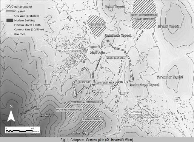
One of the principal aims of the actual project is to explore the extension of the urban area of Colophon in a diachronic way. From the excavations of 1922 by the American team we knew that the acropolis was inhabited at least from the Early Archaic time onwards until the Hellenistic period, but it remained unclear to what extent the plain between the brooks Kabaklidere and Kururdere was used as settlement area. The only model for the urban development of Colophon presented until now goes back to W. Höpfner, who proposed that in the Archaic period the territory of the city comprised the acropolis and a small strip extending to the north of the hill Halil Ağa Tepesi, on the foot of which he assumed the famous agora of the old city [3]. Thus the old city comprised only a small part of the plain to the West of the brook Kabaklidere, while he understood the larger part of the plain between the Kabaklidere and the Kurudere as the sector of the “new town” built in the late 4th c. BC. In 2013 the survey of a large area of the North-Eastern sector of the town both by walking and geophysical prospection brought evidence that the extension of the Archaic town was much larger than assumed by Höpfner and extended nearly to the Northern delimitation of the town (sector G of the later fortification walls) [4].
The survey in the South-Western area produced 453 items of pottery and tiles with a slight preponderance of pottery (234 items), which is, however, due to the existence of an illegal dig. While only some of the tiles could be identified clearly as of Archaic date by the existence of a red slip, most of the pottery fragments could be dated to the 6th/5th c. BC. Only few fragments belonged to the Hellenistic period.
The majority of the tombs was located in the area of the previously known South Necropolis, whose extent on the Kale Tepe had however been underestimated in previous surveys. Additionally, another yet unknown burial ground to the South West of the city on the eastern slope of the Sivridağ was explored, which is apparently unconnected to the South Necropolis. No pathways between the two burial grounds could be found, while the pathways leading up to the burial grounds from the city and within the necropolis areas themselves were clearly visible within the ALS data. It is however possible that an earlier connection between the two burial grounds was destroyed with the construction of the modern forest road.
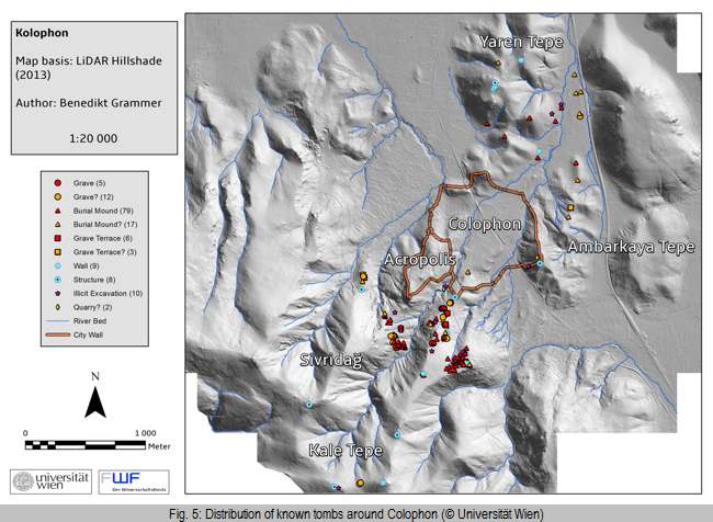
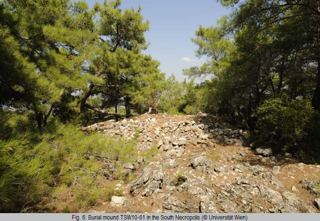
In total, about 150 archaeological features were documented, among them 95 burial mounds, 10 grave terraces, 18 simple graves and 17 walls or structures of unclear function. The size of the burial mounds varied between 3 and 20 meters in diameter, the preserved height was up to 3 meters. The mounds can be divided into two types: either heaps of earth set against the slope of the hill and covered with stones, or heaps of stones in a circular form on more level ground, which sometimes possessed retaining walls out of regular stone work (Fig. 6). As far as could be told from the illicit excavations (which affected almost all of the burials) most burials contained only a single grave, which was sometimes dug into the bedrock, and covered by flat stone slabs. The grave terraces are rectangular structures built of regular stonework, usually preserved to a height of only one or two courses. Most of the terraces were set against the steeply rising slope of the hill, providing a level ground for the construction of the graves. In the vicinity of the mounds and terraces simple graves without elaborate grave marking were also found, again mostly in a robbed state. They were only covered by a layer of smaller stones or tiles. These small markings do not show up in the ALS data unless they are robbed and it can be assumed that further graves of these types are present within the necropolis area, but are hard to discern due to the ground being thickly covered by pine tree needles.
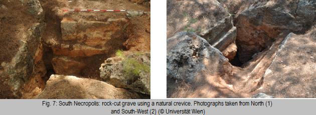
For a singular tomb in the South Necropolis a several meters deep natural crevice was used (Fig. 7). At the top of the crevice on the north and south side a very regular series of small steps has been cut into the stone, which might have been used as support for a platform, either for bearing a corpse or as cover for graves within the crevice. At the downslope to the north large rectangular blocks formed a boundary around the crevice in the form of a half circle. The tomb was heavily disturbed by several illicit excavations, but it seems likely that it was originally covered by a small heap of earth or stones, similar to the other mounds in the South Necropolis.
The dating of the monuments within the necropolis area proved to be difficult. Even though all tombs were robbed, sometimes recently, almost no fragments of pottery could be retrieved. Only one diagnostic fragment of pottery, the bottom of a probably North Aegean amphora dating to the 5th/4th century BC, was found during the survey in the South West necropolis, however without any clear connection to a specific grave. Other finds were mostly roof tiles at some of the robbed tombs, probably used originally for covering the grave. Analysis of the tiles is still pending, with a first estimate dating them probably to the Archaic/Classical period [8]. While the apparent separation of the South Necropolis and the South West Necropolis could hint at a chronological distinction in their use as burial ground, a simultaneous use of both seems likewise thinkable [9].
While no individual monument within the necropolis area can be dated at the moment, it seems likely that the South and South West Necropolis were used in Archaic and Classical times. Due to the close connection of the South West Necropolis to the Acropolis with its known Early Hellenistic phase of occupation it seems possible that the burial ground’s use extended into this time.
[1] For previous results see Ch. Bruns-Özgan – V. Gassner – U. Muss, Kolophon: Neue Untersuchungen zur Topographie der Stadt, Anatolia Antiqua 19, 2011, 199‒239; Ch. Özgan et al., Kolophon Antik Kenti 2010 Yılı Yüzey Araştırmaları, AST 29, 2012, 263‒285; V. Gassner – U. Muss – E. Draganits, Survey in Kolophon: Die Kampagnen 2010‒2012, Forum Archaeologiae 65/XII/2012 (http://farch.net); Ch. Özgan et al., Kolophon Antik Kenti 2011 Yılı Yüzey Araştırmaları, AST 30, 2013, 195-206; A. Bammer – E. Draganits – V. Gassner – B. Grammer – M. Gretscher – O. Mariaud - U. Muss, Colophon 2013, Forum Archaeologiae 71/VI/2014 (http://farch.net).
The territory of the ancient town (Fig. 1)
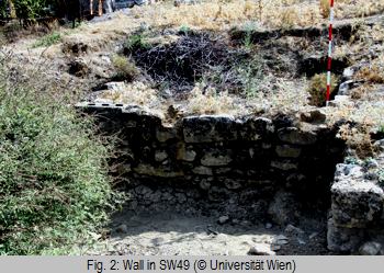 Main goal of the survey of the campaign of 2014 was the exploration of the South-Western part of the territory immediately East of the Kabaklidere brook to control if the settlement area continued also here. These gently sloping terraces were already investigated by the Izmir Museum in the late 1990s in two areas where residential buildings were found, part of which are still visible today (Fig. 2). Most probably the walls present two phases, the latter of which show large, fine worked ashlar blocks at the corners, which seem to be spolia from older structures. The unpublished reports from the Izmir Museum mention pottery from the Geometric, Archaic, Classical and even Hellenistic periods.
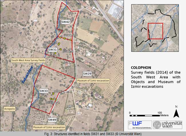
For the actual survey it was not possible to walk all fields of the area, since we were not granted permission to work on the fields immediately connected to those of the North-Eastern area of the city. We thus decided to concentrate on fields which lay near the Kabaklidere brook. In particular the fields SW31 and SW33 brought evidence for an ancient division of the area, recognizable by sporadic ashlar blocks with clearly worked edges in obvious alignment. We identified objects SW31/1-4 as indication of an East-West running wall in field SW31 and objects SW33/1-3 as an equally East-West orientated wall in field SW33, while objects SW31/5-6 belonged to a North-South running wall in the Western part of the area (Fig. 3). The locations of all these features were measured [5] and their correlation with the walls identified by the geophysical prospection of 2013 in the North-Eastern part of the city showed that they corresponded perfectly to the orientation of these structures.
Summarizing our results, both in the North-Eastern and in the South-Western sector of the urban area we have evidence for a large settlement area which according to the finds was inhabited at least in the 6th/5th c. BC, but probably also earlier in the 7th c. BC [6], while finds become more sporadic in the 4th c. BC and are widely missing in the Hellenistic period.
South Necropolis
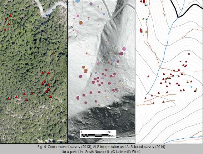
The survey within the South Necropolis area was conducted on the basis of a high resolution digital elevation model generated by the means of an airborne laser scan (ALS or LiDAR), carried out by the Austrian company Airborne Technologies. The laser scan produces an elevation model with a resolution of 0.5 meters while removing vegetation, making it highly efficient for finding surface structures in a wooded and overgrown area like the hills surrounding Colophon. In multiple visualizations of the terrain data (Hillshade, Slope, Local Relief Model and others) an interpretation of the data was carried out in a GIS (ArcGis 10.1), giving an estimate about what structures to expect in the survey area. In the field this interpretation was used for a ground check. The data was converted to a Mobile Atlas (Galileo sqlite) using the MapC2MapC software and was displayed on a tablet using the software Locus Pro. A GPS receiver (XGPS160) was used to increase the accuracy of the GPS reception in the woods. Using the tablet (Asus ME302C) for orientation in the field it was possible to conduct a very effective survey and a large amount of features could be documented within a short period of about two weeks (Fig. 4) [7].
Several smaller clusters of tombs and a number of apparently singular tombs were found on all hills surrounding the city, indicating that burials were not restricted to the specific necropolis areas (Fig. 5).
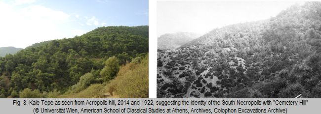
Other evidence for dating can be gathered from the documentation of the American excavations at Colophon during the 1920s. The part of the South Necropolis on the western ridge of the Kale Tepe is probably the area where Hetty Goldman excavated several tombs in 1922. The exact location of these tombs is unknown and could not be determined during the survey, but a comparison of the American photos of the so-called “Cemetery Hill” and the western slope of the Kale Tepe makes it very likely that they were found in the South Necropolis (Fig. 8). Among the graves were burial mounds and simple graves covered by stones – both types of graves could also be found during the survey. A Classical or Early Hellenistic coin and black-gaze pottery were found in these tombs on “Cemetery Hill”, which led to the designation as the 4th century necropolis of the city [10].
Yaren Tepe
An extensive survey of the Yaren Tepe, a massive hill dominating the territory to the immediate north of Colophon, was undertaken on the basis of the interpretation of the airborne laser scan. During the survey three small heaps of irregular stones could be observed, each in an isolated position on protruding ridges of the hill. These structures were roughly circular and measured about 4-6 m in diameter; according to their close similarity to the burial mounds of the South Necropolis they may likewise be interpreted as single, highly visible funerary monuments. Furthermore a very deteriorated structure of unclear function could be documented that seemed to consist of low quality walls made of rubblestones. In the immediate vicinity fragments of roof tiles with red paint could be observed; the form of the side ledge of one of them seems to indicate a dating to the 6th or 5th c. BC, though further study will be needed to determine this with more certainty [11]. Finally, at the highest point of the hill another massive structure of rubblestones was found, being slightly oval in form and measuring about 10-12 m at its maximum diameter. Its definite form being difficult to determine due to the thick cover of vegetation, it remains unclear whether this was originally another burial mound, fortified position, observation point or a sort of platform of unknown function. Nevertheless this structure commands a strategic position to the north of Colophon – vast parts of its territory are visible from here while in turn the structure itself is highly visible from both the city and its approaches. The importance of this point seems to be further strengthened by the observation of two parallel terracing walls of large blocks that articulated the area below the structure to the south.
[2] The campaign took place from the 5th to 27th September 2014. Participants of the Austrian research team were Anton Bammer, Verena Gassner, Benedikt Grammer, Martin Gretscher, Ulrike Muss (archaeologists, University of Vienna, Austria), Erich Draganits (geologist, University of Vienna, Austria); Olivier Mariaud (historian, University of Grenoble, France) and – as a guest – Luigi Vecchio (epigraphist, University of Salerno, Italy). Our warm thanks go to Christine Özgan and her team for the possibility of collaboration. The project is financed by the Austrian FWF (P 24763-G 21).
[3] W. Höpfner, Ionien. Brücke zum Orient (Darmstadt 2011), 120–125, Abb. 68. Similar W. Höpfner, Geschichte des Wohnens 1 (Ludwigsburg 1999) 279–291, map on p. 284.
[4] See A. Bammer – E. Draganits – V. Gassner – B. Grammer – M. Gretscher – O. Mariaud - U. Muss, Colophon 2013, Forum Archaeologiae 71/VI/2014 (http://farch.net) fig. 1.
[5] The geodetic surveying lay in the hands of Kamran Citak and collaborators (Mira Harita, Selçuk/Turkey).
[6] For evidence for earlier finds see Ch. Bruns-Özgan – V. Gassner – U. Muss, Kolophon: Neue Untersuchungen zur Topographie der Stadt, Anatolia Antiqua 19, 2011, 199-239, in particular 230–239.
[7] We would like to express our gratitude to Erich Draganits and Olivier Mariaud for their assistance in the conduction of the ALS-based survey and their help in documenting the finds.
[8] Preliminary classification of the pottery provided by V. Gassner.
[9] Simultaneous use of separate burial grounds is well attested at Klazomenai, see: B. Hürmüzlü, Burial grounds at Klazomenai. Geometric through Hellenistic periods. In: Klazomenai, Teos and Abdera. Metropoleis and Colony. Proceedings of the international symposium, Abdera 20-21 October 2001 (Thessaloniki 2004) 77-95.
[10] H. Goldman, Excavations of the Fogg Museum at Colophon, AJA 27/1, 1923, 68.
[11] Preliminary pottery report by V. Gassner.
![]() © Ulrike Muss, Verena Gassner, Benedikt Grammer, Martin Gretscher
© Ulrike Muss, Verena Gassner, Benedikt Grammer, Martin Gretscher
e-mail: ulrike.muss@univie.ac.at
This article should be cited like this: U. Muss ‒ V. Gassner ‒ B. Grammer ‒ M. Gretscher, The Colophon Survey 2014, Forum Archaeologiae 73/XII/2014 (http://farch.net).