| Forum Archaeologiae - Zeitschrift für klassische Archäologie 19 / VI / 2001 |
This paper gives an overview on the recently granted EU project 3D MURALE which stands for 3D Measurement & Virtual Reconstruction of Ancient Lost Worlds of Europe, Project Number: IST-1999-20273. This project aims to virtually reconstruct a complete archaeological site including landscape, buildings, and artifacts in 4 dimensions, where the 4th dimension stands for the time component. It should be possible to see also the history of the site from its beginnings to its destruction in order to understand the historic significance of the site. Finally this technique should be applicable to any archaeological site serving three purposes: for visitors at the site to see how the remains could have looked like in reality, for virtual tourists to see what can be seen on spot, and for archaeologist to ease their work in respect to reconstruction and classification of artifacts and buildings. Since the project recently started (Nov2000), no actual results can be presented; however, the main project goals are presented.
Both these aspects of the project will help to produce records and visualizations that are more complete and scientifically precise. A first goal is to register in situ all stratigraphical evidence (an archaeological site is excavated layer by layer so-called stratas resulting in a sequence of strata), as archaeological fieldwork by its nature destroys this kind of information. The 3-D recording techniques should replace present techniques of 2-D recording, which only offer a piecemeal representation and are both time consuming and labor intensive. Secondly, techniques need to be developed to build 3-D models of artifacts, mainly for cataloging and visualization, and of sculptures and buildings, mainly for restoration and visualization. Thirdly, the terrain of the site needs to be modeled in 3-D as such topographic data yield important information for the archaeologists and is vital for a realistic visualization. Finally, an integrated model must be built of the landscape, the buildings, and the artifacts and this for different eras, showing reconstructions for these periods or the current state. To summarize following main objectives can be identified:
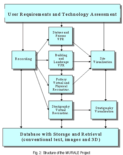
MURALE will also provide tools for the virtual and real restoration of artifacts, sculptures, and buildings. Today, undecorated, heavy building elements or fragments can only be joined/pieced together by time-consuming trials with the help of heavy hoisting equipment. By creating the means to easily create 3-D models of the parts, it becomes possible to virtually puzzle them together first and to save a substantial amount of time. Today, the completion of large sections of buildings by means of newly carved or cast elements is avoided as much as possible. Rebuilding a ruined structure should only be decided, when more than 90% of the original building elements are preserved so that their anastylosis becomes possible. In this case, the new 3-D technology will check in virtual reality the level of completeness first. In most cases, however, anastylosis is no longer possible, so that the look and/or function of a ruined structure remain beyond reach of non-specialized audiences. Fig. 2 shows the structure of the MURALE project.
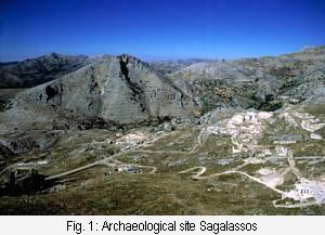 New technologies are introduced to old research areas and provide new insights for both the researchers and people interested in this field. This statement can be proofed especially in the field of archaeology, since there are many researchers in that area who already use new technologies and there are many people interested in the field of archaeology since so-called archeo parks have an increasing number of visitors. Since we have some experience in applying technical knowledge to the field of archaeology, especially in the field of ceramic reconstruction and classification [SM96, KS99, KS00] and others in the reconstruction of archaeological buildings [Goo00] a consortium was founded to virtually reconstruct a site in Turkey called Sagalassos [Wae93, Waelk00].
The MURALE consortium consists of 2 industrial and 5 academic partners, from 4 different European countries (Austria, Belgium, Switzerland, and the UK). MURALE is intended to add an additional technological layer to an extensive, ongoing excavation project.
The advent of new multimedia technologies produces rich new ways of recording, cataloging, conserving, restoring and presenting archaeological artifacts, monuments and sites. The 3-D MURALE project wants to contribute to these developments and focuses on two aspects:
Archaeologists will continuously play the role of critical users, who make suggestions for improvements from their perspective. Through a direct collaboration with the whole team of archaeologists behind the MURALE project, the archaeologists will have an important influence on the objects, buildings, and sites on which the techniques will be tested. The whole MURALE technology and set of tools will be demonstrated both to specialized audiences and to non-specialized visitors. The task will be responsible for the set-up and operation of service demonstrations and the performance of the new tools. These results will be progressively collected and presented in demonstrations both on the site and elsewhere for larger European and other audiences. At the end of the project an overall service package will be delivered. It is intended that the experience and results of the project could also be reproduced in trials at other European sites and in other European collections.
Reference: This article will be quoted by M. Kampel - R. Sablatnig, On using 3D Multimedia Tools to measure, reconstruct and visualize an Archaeological Site, Forum Archaeologiae 19/VI/2001 (http://farch.net).
Acknowledgments
The authors want to thank the whole MURALE project proposal team, since an overview on such a project can only be given if techniques and ideas of many researchers involved are used. Especially we want to thank John Cosmas, Marc Pollefeys, Luc Van Gool, Desi Van Rintel, Michael Gervautz, Heinz Mayer, Peter Van Santen, Roland De Geest, and Marc Waelkens for their contributions.
[SM96]: Sablatnig R., Menard C., "Computer based Acquisition of Archaeological Finds: The First Step towards Automatic Classification", in: Moscati P., Mariotti S. (eds.), "3rd Intl. Symposium on Computing and Archaeology, Rome", vol. 1, pp. 429-446, 1996.
[KS99] Kampel M., Sablatnig R., "On 3d Modelling of Archaeological Sherds", in: Sarris N., Strinzis M.G., (eds.), "Proc. of Intl. Workshop on Synthetic-Natural Hybrid Coding and Three Dimensional Imaging", Santurini, Greece, pp. 95-98, 1999.
[KS00] Kampel M., Sablatnig R., "Computer Aided Classification of Ceramics", in: "Proc. of Intl. EuroConference on Virtual Archaeology between Scientific Research and Territorial Marketing", Arezzo, Italy, page in press, 2000.
[Goo00] Van Gool L., Defoort F., Hug J., Kalberer G., Koch R., Martens D., Pollefeys M., Proesmans M., Vergauwen M., Zalesny A., "Image-based 3D modeling: Modeling from reality", in: Leonardis A., Solina F., Bajcsy R. (eds.), "Proceedings NATO Advanced Research Workshop on Confluence of Computer Vision and Computer Graphics", volume 84, pp. 161-178, Ljubljana, Slovenia, 2000, Kluwer Academic Publishers.
[Wae93] Waelkens M. (ed.), "Sagalassos I: First General Report on the Survey (1986-1989) and Excavations (1990-1991)", Leuven University Press, 1993.
[Waelk00] Waelkens M., Loots L., "Sagalassos V: Report on the Survey and Excavation Campaigns of 1996 and 1997", Leuven University Press, 2000.
e-mail: kampel@prip.tuwien.ac.at
sab@prip.tuwien.ac.at