| Forum Archaeologiae - Zeitschrift für klassische Archäologie 86 / III / 2018 |
The area under exam represents a portion of coastal territory of Tuscany comprised between the rivers Cecina in the south and Fine in the north. While nowadays it belongs to the Livorno province, in roman era that area was a part of ager Volaterranus, the territory belonging to the town of Velathri/Volaterrae. This was a dynamic area crossed by two main roads: one, the via Aurelia (2nd century BC), running along the coast, and one, the via Aemilia Scauri (115–109 BC?), in the inner part of the plain, at the border with the foothills. Long-range trade was implemented through a system of anchoring sites scattered throughout the coast between the mouth of the two rivers, and protected by a complex system of shoals, as also described by the poet Rutilius Namatianus in the early 5th century BC (1, 453ff.). The main settlement of the area was Vada Volaterrana, known from itinerary sources, such as Itinerarium Maritimum and Tabula Peutingeriana, and excavations, like the one in S. Gaetano, in the north of the modern town of Vada. Furthermore, wealthy villas were present in that territory: a few of them have been discovered through archaeological excavations, such as the Villa di San Vincenzino, a large coastal villa located on the left bank of Cecina river, which dates between 30/50 BC and 5th century BC.
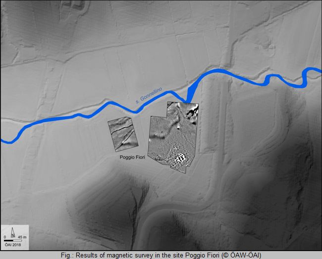
All three investigated sites have given a positive response regarding the presence of human structures, particularly revealing different settlement patterns certainly connected with the transport routes. So far the best prospecting results have been obtained in the site of Poggio Fiori (fig.), where an antique ceramic production center has been detected. The magnetic data collected on that site show the presence of two main rectangular kilns, surrounded by three smaller ones, located within an enclosure where numerous other anomalies are scattered in a radius of 50m.
In summer 2016, ÖAW-ÖAI, in cooperation with Laboratorio Universitario Volterrano and Soprintendenza Archeologia, Belle Arti e Paesaggio per le Province di Pisa e Livorno, has undertaken a campaign of geophysical prospections in the above area. The sites' selection process was completed in compliance with the results of several field surveys, carried out between 1980 and 2005 by the University of Pisa research team. Within the selected sites two, Capo di Villa and Vallescaia, are located close to the coast, along the supposed path of via Aurelia; whereas the third site, Poggio Fiori, is located in the hinterland, not far from the river Fine and the path of via Aemilia Scauri.
For further information please visit
https://www.oeaw.ac.at/oeai/forschung/militaerische-infrastruktur-und-verkehrswege/via-aurelia-siedlungsentwicklung/ and/or contact: ivan.repetto@oeai.at
![]() © Ivan Repetto
© Ivan Repetto
e-mail: ivan.repetto@oeai.at
This article should be cited like this: I. Repetto, Geophysical surveys along the Via Aurelia in northern coastal Etruria. The sites of Capo di Villa, Poggio Fiori and Vallescaia, Forum Archaeologiae 86/III/2018 (http://farch.net).